
Ten accessible walks in Cumbria: big views and room to explore


There is something about Cumbria that makes me breathe a little deeper. Perhaps it’s the mountains, the water or the chance to switch off and watch the clouds doing something dramatic. They do enjoy a performance up here.
As a wheelchair user, I know that finding a suitable walk takes more than spotting the words “easy route”. Easy for whom? A short path with a steep slope can demand far more than a longer outing on a good surface.
But there are wonderful opportunities to explore, whether you use a manual wheelchair, need an all-terrain mobility scooter or simply prefer a walk with fewer obstacles.
Here are five routes to inspire your next adventure. Five are in the Lake District, while the other five are dotted around Cumbria
1. Threlkeld to Keswick: follow the old railway

There’s something rather satisfying about a railway walk. Someone else has already done the hard work of finding a way through the landscape, leaving us to enjoy the scenery.
The Keswick to Threlkeld Railway Trail follows the River Greta gorge, with woodland, bridges and plenty of reasons to pause. You can begin at either end, and an out-and-back outing means you can choose a turning point that suits your energy levels.
The National Park describes the full trail as approximately 10km return and grades it as a Miles Without Stiles “for all” route. The improved surfaces and gradients were designed with different mobility needs in mind. Remember that you’ll be sharing the route with cyclists and other walkers.
This is a lovely option for anyone who wants to spend time travelling through a landscape, with the river providing the soundtrack.
Access update, October 2026: A bridge at the Keswick end closed on 22 September for work expected to last up to eight weeks. Much of the trail remains open towards Threlkeld, but the usual through journey is interrupted. Check the National Park’s closure map and alternative entry points before setting off; don’t assume a diversion will suit your wheelchair.
2. Tarn Hows, near Coniston: take your time beside the water

Tarn Hows is the sort of place that can make a short walk take a very long time. There’s another view around every bend, and it would be rude to rush past it.
Water, trees and surrounding fells come together beautifully here. Pack a flask, allow time to linger and resist the temptation to judge the outing by how quickly you finish.
For this accessible option, start at the Tarn Hows National Trust car park. I’m describing the circuit around the tarn, rather than the longer walk uphill from Coniston.
The National Trust lists the circuit as approximately 1¾ miles. The track is suitable for wheelchairs and buggies, although there are short hilly sections, so some manual wheelchair users may need assistance. Tramper all-terrain mobility scooters are available; arrange one ahead of your visit.
A Tramper can make the difference between wondering whether you’ll manage the slopes and being able to enjoy the outing alongside your companions. That shared experience matters.
And with scenery like this, everyone deserves the chance to stop and say, “Just look at that.”
3. Whinlatter Forest: an adventure among the trees

I love being in a forest. The scent, the shifting light and the sound of wind moving through the branches all encourage me to slow down.
Whinlatter adds a mountain setting to the mix. Forestry England describes it as England’s only true mountain forest, with views across the northern Lakes.
For visitors who need mobility support, all-terrain scooters can be booked in advance through Outdoor Mobility. The usual Wow Trail is four miles long, with surfaced paths at least two metres wide and gradients reaching 1:7. Those slopes make it important to choose equipment suited to the terrain; a surfaced path doesn’t necessarily mean an easy push in a manual wheelchair.
This is an outing to plan with the visitor team, who can help you choose a route that matches your needs and the conditions.
Access update, October 2026: Forestry work currently affects the Wow Trail. Forestry England’s update of 16 October says it is open as a linear route to the wildlife hide and viewpoint, with a signed diversion. Ask the team whether the current diversion suits your mobility equipment before starting.
4. Smardale Gill: a railway walk with a spectacular reward

Smardale sits near Kirkby Stephen, outside the Lake District National Park. I’m including it because a good accessible adventure deserves a little flexibility with the map.
Here, an old railway takes you through a landscape of woodland, steep valley sides and open views. The star attraction is Smardale Gill Viaduct, carrying the route high above Scandal Beck on its sweeping stone arches. It’s a wonderful place to pause and imagine the trains that once passed through.
Cumbria Wildlife Trust now describes a wheelchair and pushchair accessible surface from the Smardale car park towards Newbiggin-on-Lune, with ramps at both ends. This is useful updated information: older route accounts describe rougher ground beyond the viaduct. Check the Trust’s current guidance when choosing how far to go.
For a manageable outing, choose an out-and-back section, allowing enough energy or battery power for the return. Reaching the viaduct can provide a satisfying destination without committing to the entire reserve.
Bring something to eat and give yourself time to enjoy being there. A picnic with a view is a perfectly respectable reason to stop.
5. Latrigg viewpoint: mountain scenery with an honest access warning
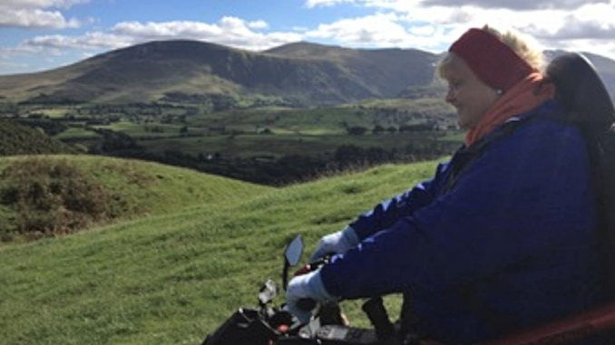
If you’re looking for a big view, Latrigg delivers.
The limited mobility route begins at the car park at the head of Gale Road, above Keswick. From here, the viewpoint offers a glorious outlook across Keswick, Derwentwater and Borrowdale. It’s the sort of scene that makes conversation briefly unnecessary.
However, this is the most demanding access option on this list. The National Park grades it “for some”, with approximately 1km each way. The compacted stone path includes a 150-metre stretch at a gradient of 1:7, followed by sections around 1:10. It specifically advises against the route for people propelling their own manual wheelchairs. Any mobility equipment used needs to cope with both the climb and the descent.
The accessible outing goes to the viewpoint, where you turn back. The onward path towards the summit is steep and uneven. There are no toilets or refreshments on the walk; the nearest facilities are in Keswick.
With suitable equipment and the right conditions, this offers the chance to enjoy that wonderful feeling of being up among the fells.
6. Orrest Head: woodland, Windermere and a wonderful view

Orrest Head offers that lovely moment when you emerge from the trees and the landscape suddenly opens out. Windermere stretches below, surrounded by the Lakeland fells. Definitely somewhere to put your phone down after taking the photograph and simply enjoy being there.
The accessible route starts beside the lower entrance to the Windermere Hotel, close to Windermere railway station. Follow the blue signs through Elleray Wood towards the summit; the alternative red routes include steps. Allow for approximately 3.5km there and back, with around 120 metres of ascent.
Now for the detail that matters: this is a hill, and the improved path still has some demanding slopes. The National Park grades it “for some”, with the steepest section near the start reaching 1:4. A suitable all-terrain mobility scooter needs a full battery and the ability to manage those gradients, including the return downhill. This isn’t a gentle manual wheelchair outing.
With equipment suited to the climb, there’s a wonderful reward at the top: panoramic views and specially designed benches where you can take your time before returning the same way.
I’m all for a summit that encourages a good long pause. You’ve come for the view, after all — give it your full attention.
7. The Thrang to the Watercut: big skies in Mallerstang
If you enjoy wide-open landscapes, put this one on your list. Mallerstang has room to breathe, with sweeping hillsides and views that deserve much more than a passing glance.
Although it’s in Cumbria, this valley lies within the Yorkshire Dales National Park. From The Thrang, the route follows the Pennine Bridleway uphill to the Watercut, a striking stone sculpture by Mary Bourne. Wild Boar Fell provides a magnificent backdrop across the valley.
The sculpture looks perfectly at home here, its cut opening framing a little piece of the landscape. It gives you a destination to aim for, followed by a very good excuse to stop and admire your surroundings.
Allow a little over two miles for the return trip. It’s just over a mile uphill to the sculpture, so this is an outing for a robust all-terrain wheelchair or mobility scooter capable of managing both the climb and the descent. The bridleway is generally good, but it isn’t a level, surfaced promenade.
There is limited parking at The Thrang, beside the B6259 approximately three miles south of Nateby, at grid reference NY783004. There are no facilities along the route, so plan your toilet stop before arriving and bring refreshments.
Pack an extra layer, too. A view this good deserves time, and it’s much easier to appreciate it when your ears aren’t freezing.

8. Friar’s Crag, Keswick: lakeside scenery at a gentler pace

Sometimes you want mountain views without a mountain climb. The shores of Derwentwater offer a lovely opportunity to slow down, watch the water and enjoy the fells rising beyond.
Starting at the Theatre by the Lake car park, this route follows the foreshore towards Friar’s Crag, with views towards Cat Bells and Borrowdale. There are opportunities to explore a little woodland along the way, too. It’s the sort of outing where a flask and an unhurried afternoon make excellent companions.
Access update, October 2026: Although older descriptions call this wheelchair friendly, the National Park currently reports potholes, rough surfaces and small steps up to 70mm. It says the route currently meets only its “for some” standard. Crucially, the final approach to the Friar’s Crag viewpoint is damaged and described as unsafe for people on wheels. Avoid that section until repairs are confirmed.
For now, plan a shorter lakeside outing suited to your equipment and check current conditions before travelling. The National Park describes the wider out-and-back route as approximately 2.5km, but there’s no need to complete it to enjoy time beside the lake.
The starting area has Blue Badge parking and accessible toilets, with refreshments nearby. That makes it easier to combine some fresh air with a welcome sit-down and something tasty. I find cake fits most itineraries remarkably well.
9. Engine Lonning, Carlisle: woodland with a story to tell

An adventure doesn’t always need a mountain backdrop. Sometimes a patch of woodland on a city’s doorstep offers just the escape you’re looking for.
Engine Lonning lies west of Carlisle city centre, beside the River Eden. Once home to the Canal Shed locomotive yard, this green space combines nature with reminders of the people and steam engines that helped shape its history.
A newly completed accessible heritage trail has brought upgraded paths and resting places to the woodland, making it easier for wheelchair users and families with pushchairs to explore. Sculptures, stone carvings and wildlife mosaics celebrate the area’s Roman, railway and natural heritage. There’s plenty to catch your attention — a good excuse for anyone who enjoys stopping every few minutes.
Look out for waymarkers made from donated railway track and a Roman coin-inspired picnic table designed with space for wheelchairs underneath. Practical access woven into something creative: that’s lovely to see.
Plan your arrival carefully: there is no dedicated on-site parking or toilet provision. Check the entrance and approach that best suit your needs before travelling. The wider riverside paths are separate from the improved woodland trail, and some approaches include steps, so don’t assume every connecting route is wheelchair accessible.
This is a chance to enjoy a shorter woodland outing, discover a little local history and take your time. Sometimes that’s exactly the adventure a day needs.
10. Bitts Park, Carlisle: gardens, riverside views and family time

Bitts Park is a lovely reminder that an outdoor adventure can begin close to a city centre. With formal gardens, mature trees and walks beside the River Eden, there’s plenty of space to slow down and enjoy a little greenery.
The park’s flat, surfaced paths offer a choice of circular outings, so you can choose a distance that suits your energy levels. Take a wander through the flower gardens, pause beside Queen Victoria’s statue or spend a quiet moment in the Garden of Memories. There’s no need to march around ticking everything off. The flowers certainly aren’t going anywhere.
For families, the inclusive play area adds another reason to visit. Cumberland Council lists a wheelchair accessible swing and trampoline, play panels, musical instruments and a seasonal splash park. It’s lovely to have opportunities for children to join in together.
Access and planning: Keep to the surfaced park paths and choose your own circuit rather than committing to a longer riverside route. There is a car park at Bitts Park and public toilets on Dacre Road; check opening times and any specific toilet access requirements before travelling.
This is an outing for enjoying the simple things: fresh air, good company and time outdoors. Add a picnic and you could find that your short stroll becomes a rather lovely afternoon.
Find the walk that works for you
For me, access information is about confidence. Knowing where to start, what the surface is like and whether there’s a steep section helps turn “I wonder if I could” into a day out.
Before travelling, check the latest route information, arrange any mobility hire and make sure the distance suits your needs. Accessible means different things to different people, and there’s no prize for going further than feels comfortable.
Take the photographs. Enjoy the flask of tea. Spend ten minutes watching the light move across a hillside.
You belong in these landscapes too.


Comments